


United Kingdom Map
Contest Access
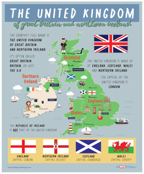
What is the United Kingdom? Which countries compose it? What is the difference with Great Britain? This infographic map is the perfect visual introduction to answer all these fundamental questions! Clear, simple, and colorful, it allows students to visualize the geography and composition of the United Kingdom at a glance. It is an indispensable resource for any introductory lesson on British culture and civilization.
Your Classroom Poster
A ready-to-use visual aid for your classroom. Download this high-definition poster to print.
To download this material, you must be logged in with a teacher account registered for The Big Challenge competition.
Pedagogical Guide
Objective & Resource Content
The objective is to enable students to identify the **four countries of the United Kingdom**, name their respective capitals, and understand the difference between the United Kingdom and the **Republic of Ireland**.
The document is an infographic map of the United Kingdom ("**THE UNITED KINGDOM**"). It visually and textually explains that the U.K. is composed of four countries:
- **England**, capital: **London**
- **Scotland**, capital: **Edinburgh**
- **Wales**, capital: **Cardiff**
- **Northern Ireland**, capital: **Belfast**
The poster clarifies that the full official name is "**The United Kingdom of Great Britain and Northern Ireland**" and specifies that the Republic of Ireland is not part of it. The map also shows the location of other major cities like Liverpool, Manchester, and Glasgow.
Suggested Lesson Flow
Before the Activity (~5 min): U.K. BRAINSTORMING
-
Ask students what they know about the United Kingdom. Which countries are part of it? What is the capital? This allows them to activate their knowledge and correct misconceptions.
During the Activity (~10-15 min): DISCOVERING THE MAP
-
Project the infographic or hand out copies.
-
**Task 1:** Ask students to find and name the four countries of the United Kingdom.
-
**Task 2:** For each country, ask them to find the capital.
-
**Task 3:** Point to the Republic of Ireland and ask: "Is this country part of the UK?". Read the boxed text together that clarifies this point.
After the Activity (~10 min): GEOGRAPHY QUIZ
-
Ask simple questions based on the map: "What is the capital of Scotland?", "Is Liverpool in England or Wales?", "What is the full name of the UK?".
-
Students can answer orally or on small whiteboards.
Adaptations
-
**To Simplify:** Provide students with a blank map of the United Kingdom. They listen to the teacher and color the four countries different colors, then write the name of the capital.
-
**To Extend:** Ask students to do a short research project on one of the four countries to find its flag, a famous monument (that is not on the map), or a famous person who is from there.